Leigh’s ‘Panorama of the Thames’
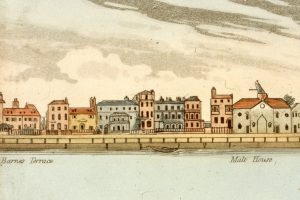
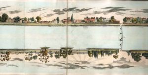
This magnificent panorama was published by Samuel Leigh in 1829, titled ‘The Panorama of the Thames from London to Richmond, Exhibiting every Object on both Banks of the River, with a concise description of the most remarkable places and A General View of London’, it cost £1/8s plain and £2/16s colour. Leigh, of 18 Strand, London, was a bookseller who specialised in panoramas, as well as guide books and phrase books for those venturing abroad. Panoramas were popular among the more affluent Georgians. The panorama shows the river from Westminster Bridge to Richmond Hill, covering a fifteen mile stretch. It depicts the houses and buildings on each bank, with the names of the householders or businesses. The panorama consists of forty-six printed copies of hand-painted water coloured sections, which are folded into a concertina and stored in a hard back case. They were created by Leigh over the two previous summers, when he had made frequent trips on the new steamboats up the river, making sketches. Accompanying it is a smaller panorama titled ‘View of London from the Adelphi’ by artist John Clarke, which was painted from an upper floor of the Adelphi and shows Central London.
This was a novelty panorama, designed to be used by tourists as they steamed up the Thames, allowing them to identify the houses and occupants as they went past. Leigh also published an accompanying booklet ‘Description of the Most Remarkable Places between London and Richmond to Accompany the Panorama of the Thames’, in which he says of the panorama, ‘The result is now laid before the public in this attempt to convey an idea of the scenery on both banks of the Thames, as viewed in an aquatic excursion from London to Richmond’. The booklet contains information about the history and residents of some of the buildings and settlements that appear, along with a list of every building illustrated, and could be read alongside viewing the panorama, and while cruising up the river. It was not only aimed at tourists, but also at the householders who owned properties that appeared on the panorama.

The last section travels through Barnes, Mortlake, Kew and finally Richmond. It has not just the villas and mansions of the wealthy that are shown, but public houses such as The Ship in Mortlake, and the White Cross and original Three Pigeons in Richmond; industrial buildings such as the Mortlake Malt houses and Warings Brewery in Barnes; bridges; ferries; churches, for example St. Anne’s in Kew; schools for instance The King’s School in Kew; and more unusual features such as The Richmond Observatory and obelisk, and the Kew Gardens Pagoda. In addition it shows life on the river, with boats of all types from small fishing boats and ferries, to larger rowing boats and sailing boats, and early steamers. It provides a unique snap shot of the river and its residents in the middle of the industrial revolution, with factory chimneys and steam boats, but as yet no railway and embankment of the river.

The historical information it provides is enormous, but it is also a decorative item; one which would have graced a wealthy Georgian household, a luxurious precursor of the coffee table book, a beautifully illustrated travel and history book featuring famous buildings as well as the homes of the rich and famous. We are lucky enough to hold three copies of this wonderful document in the Local Studies Library & Archive: one complete coloured copy with the General View of London and booklet, one incomplete coloured copy with only the panorama, and one plain copy with only the panorama. The copies are available to view if you would like to pay us a visit.
You may also view it online by visiting the Richmond section of the Panorama of the Thames Project website.
[Lara Bond, Heritage Assistant]
