
Middlesex: the county that vanished?
The Oxford Companion to British History describes Middlesex as “one of the smallest, oldest and strangest of counties”.
Counties
Counties (also called shires, hence Cheshire, Lancashire, Yorkshire) have a long history and were the main unit of provincial government in England dating back to before the Norman Conquest of 1066. The Domesday Book describes 32 shires. Each county, or pair of counties, had a sheriff ( shire-reeve) appointed by the monarch to collect revenues and administer justice via the county or shire courts.
As sheriffs were often high-handed and accused of maladministration- the fictional Sheriff of Nottingham depicted this- and the crown’s solution was to spread their powers to justices of the peace and since C16th sheriffs have been mainly county figure heads. The justices of the peace slowly gained more powers and their quarter sessions and assizes administered justice. These were abolished by the Courts Act 1971.
The English settlers took the idea of counties with them and counties are to be found in Canada, Australia and American. US states are divided into counties, though sometimes they are known as parishes or boroughs, and each county has it county seat. In Arizona you have various counties such as Maricopa, Pima and Gila. Phoenix is the state capital and is also the county seat of Maricopa county. Each county has an sheriff, who is usually elected, who performs duties for the county courts such as as administering the county jail, serving warrants, etc. In some counties the sheriff and their deputies are also the local police force.
Fictional counties include: Thomas Hardy’s Wessex , Borsetshire in the radio soap The Archers and Barsetshire the setting for Anthony Trollope’s Barsetshire Chronicles.
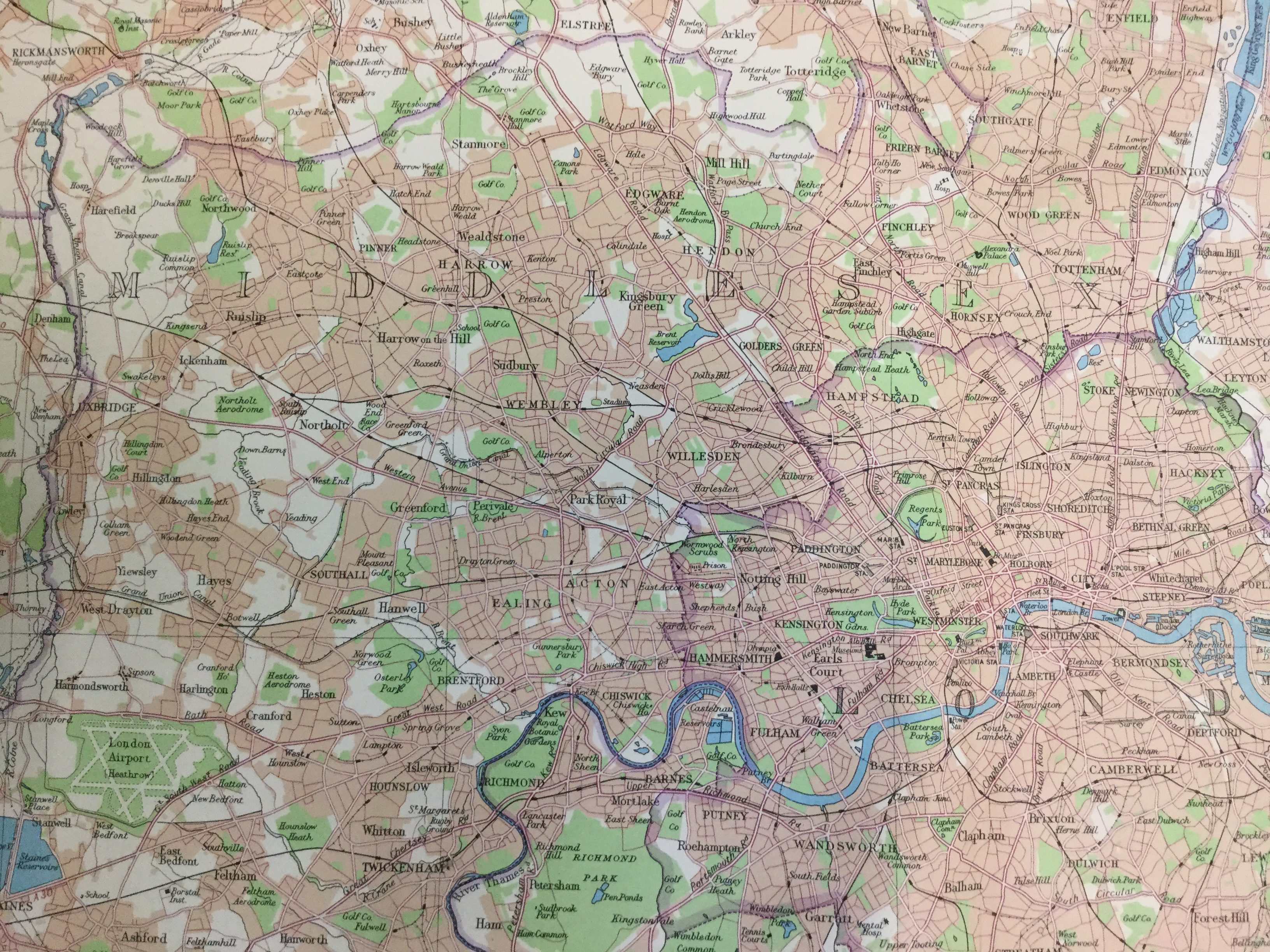
The county of Middlesex
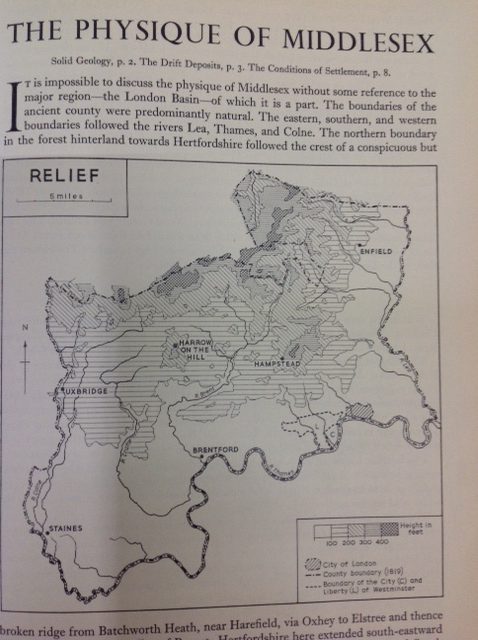
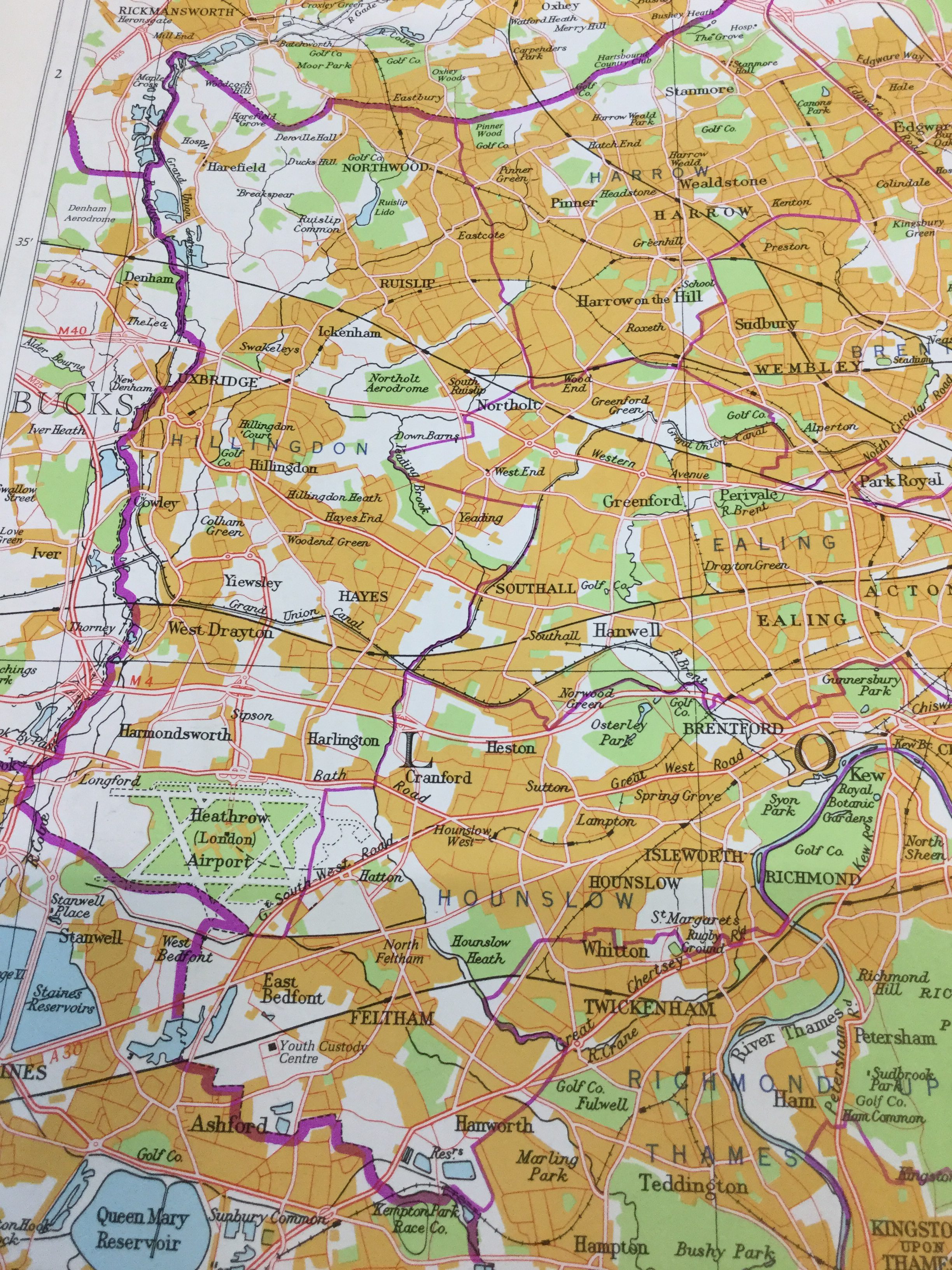
According to the London Encyclopaedia Middlesex was the county of the Middle Saxons with the name Middlesex first appearing in a charter of AD 740. Its boundaries were the River Thames to the south, River Colne to the west and the River Lea to the east with the northern boundary running along the ridge of the watershed of the rivers Brent and Colne. The county was in the Domesday Book and it was divided into six hundreds (these were subdivisions of the county) which were Edmonton, Elthorne, Gore, Hounslow, Ossulstone and Spelthorne. Middlesex was mainly agricultural, with the alluvial soil of its boundary rivers, and the clay of the Thames Basin, providing ideal for market gardens which provided food for the county and the City of London.
Middlesex was always in the shadow of the City of London- its powerful neighbour – and The Victoria County History of Middlesex says that this is why the county had no important towns, and an “absence of county nobility and gentry”. The City of London and the county were closely linked and shared the same county sheriff. The City was granted the right to appoint the sheriff of Middlesex in the C12th, and the assizes were held at the Old Bailey in the City, and fiscally they were indivisible.
Even navigating the across the county was difficult as the focal point of London meant major routes radiated out bisecting the county (London was the starting point for the Roman roads of Watling Street and Ermine Street) and this made travelling from west to east, or vice versa difficult, and when the railways arrived it was the same. So, the towns of the county existed in isolation. In the C20th the building of the M25, and the notoriously busy North Circular, made travelling from west to east easier but even today travelling from Enfield to Uxbridge on the Underground is convoluted.
As London grew the villages and towns of Middlesex, such as Hammersmith, Chelsea and Edmonton, were slowly swallowed up and became suburbs of London.
Local government
Local government in counties was the run by parish vestries of householders, who often met in the church vestry, hence the name. In the City of London local government developed through the various wards and and the vestries mainly dealt with church matters. When London began to spread outside the wall of the City the Corporation refused to to take responsibility for the new suburbs so Lambeth, Camden and Marylebone also had vestries.
Metropolitan Board of Works, established by the 1855 Metropolis Management Act, was the first metropolitan-wide local authority for London and covered the area that was to later become the County of London, which included parts of Middlesex. The Act made the vestries elected bodies with each vestry choosing the members who sat on the Board. The City of London was not included under its jurisdiction. Sir Joseph Bazalgette was the Board’s chief engineer to whom we owe the creation London’s sewerage and drainage system.
The Local Government Act of 1888 created 62 county councils in England and Wales, with 61 towns, with populations over 50,000 inhabitants being given county borough status. Amongst these were Middlesex County Council and London County Council
London County Council came into existence in 1889 and it was as a successor to the Metropolitan Board of Works. It was the first metropolitan authority to be elected directly by the people of London. Its powers slowly increased over the years of its existence and it controlled education, housing (jointly with the metropolitan borough councils), building control, public transport and public health. When it was created Hammersmith, Highbury and Hampstead, and other parts of Middlesex, were subsumed into the County of London.
It needs to be remembered that before the various parliamentary reforms acts of the C19th and early C20th, very few of the population were able to vote and power lay in the hands of the aristocracy and the middle classes. The 1832 Reform Act only granted the vote to male householders who lived in houses with a rateable value of £10 a year, and it wasn’t until 1928, nearly a hundred years later, men and women over the age of 21 was entitled to vote.
The 1894 Local Government Act created urban and rural district councils, and parish councils for villages of over 300 inhabitants, and the Act granted women the right to vote and stand for these councils. These councils had different responsibilities to the county councils and covered smaller areas. Parts of Middlesex which didn’t come under the London County Council would have had urban district councils.
After the Second World War the growth of London continued, as it had done between the wars, and the suburbs grew and swallowed up more land. As the conurbation grew it became clear that London and the surrounding areas needed to be governed by one body, as well as by the metropolitan boroughs, so as to ensure that the capital city developed and functioned efficiently and for the benefit of all its citizens, for government and business.
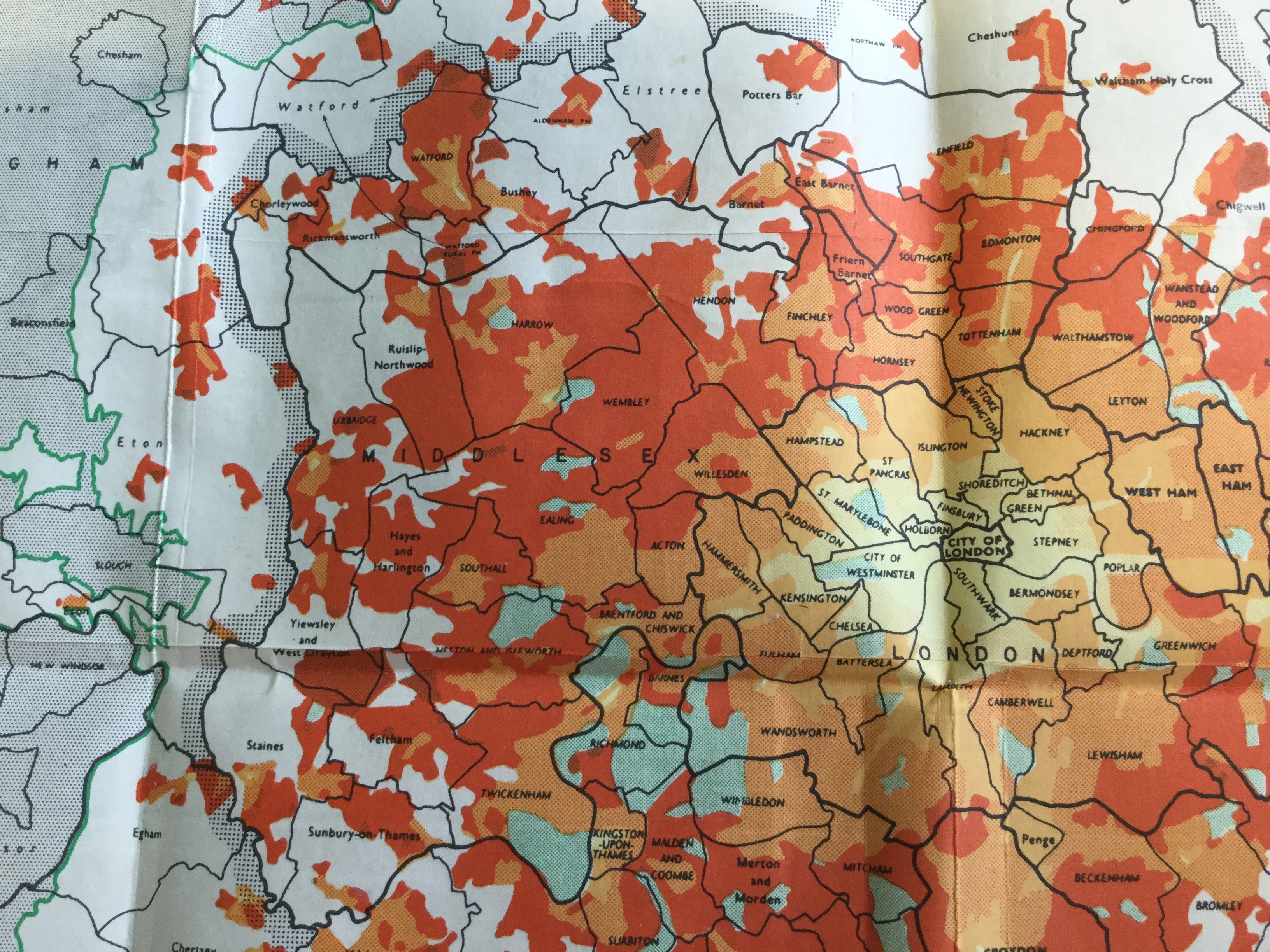
The Royal Commission on Local Government in Greater London 1957-60 examined the options for the future of London and was published in 1960. The report looked in details at the history of local government in London, the growth of London, examined the nature and purpose of local government, and looks at all areas that came the remit of local government. The report produced detailed conclusions and recommendations which proposed the creation of the Greater London Council, and the amalgamation of metropolitan boroughs and urban district councils to form 32 London boroughs while the City of London retained its unique status.
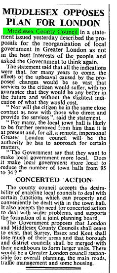
Middlesex County Council, which faced extinction, naturally opposed these plans but to no avail and on 1st April 1965, in the shorthand of the Times quoted above, the county of Middlesex disappeared altogether when Greater London was created. The parts of the County Council area that didn’t fall under Greater London were incorporated into Surrey and Hertfordshire.
Bibliography
London Encyclopaedia
Oxford Companion to British History
The Royal Commission on Local Government in Greater London 1957-60
Times Atlas of the World plate 55 1955
Times Atlas of the World plate 55 1990
Victoria County History Middlesex Vol 1
Victoria County History Middlesex Vol 2
Library members can access the entries in the Oxford Dictionary of National Biography and for the people listed above by clicking on the hyperlinks in the text.
Information on the parts of Middlesex that became part of the Borough of Richmond upon Thames can be found in the Local Studies Collection.
Postscript
This article has been modified in the light of comments received and we are grateful to the contributors.
We have subsequently added links to some other websites which encourage “the use of the historic counties in postal addressing, in guide books, on boundary signs and maps and encourage their further use as a basis for sporting, social and cultural activities and organisations….
As stated on the Gov.uk website “Middlesex County ceased as an administrative council in 1965. The former area of Middlesex now corresponds to much of Greater London and parts of Berkshire, Hertfordshire and Surrey. Middlesex is still used in the names of organisations based in the area, such as Middlesex County Cricket Club and Middlesex University.”
County Wise – a website which exists to assist and enable organisations, the media and public to use the historic counties as a standard geography for the United Kingdom.
British County Flags – a site which celebrates the county flags of Great Britain.
The Real Counties of Britain / Russell Grant
[Fiona Campbell, Library Assistant / Robert Jones, Learning Manager]